
Cochrane’s growth is guided by a coordinated set of plans, policies and guidelines. Together, these documents help manage development, support community goals and ensure decisions align with provincial legislation and local priorities.
All planning documents operate within the framework of Alberta’s Municipal Government Act, which provides the legal authority for municipal planning.
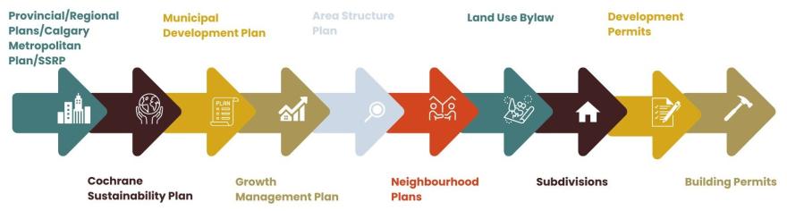
Types of planning documents
Planning documents fall into two main categories.
Statutory plans are formal documents that municipalities are required to adopt under the Municipal Government Act to support long-term planning and development, including:
- Municipal development plan, which applies town-wide
- Intermunicipal development plans, prepared with neighbouring municipalities
- Area structure plans, used for new growth areas
- Area redevelopment plans, used for existing developed areas
Non-statutory documents provide additional guidance to support decision-making. While not required by legislation, they help implement statutory plans and the land use bylaw.
These documents may be approved by Council resolution or implemented by Town administration.
Regional Plans
- South Saskatchewan Regional Plan 2014-2024
Under the authority of the Alberta Land Stewardship Act, the South Saskatchewan Regional Plan establishes high-level direction for land and resource management across multiple municipalities in the region. Municipal planning documents must be consistent with this regional plan.
Intermunicipal Plans
- Town of Cochrane/M.D. of Rocky View Intermunicipal Development Plan
The Town of Cochrane/M.D. of Rocky View Intermunicipal Development Plan is a collaborative statutory plan that guides land use, transportation, and servicing in the shared boundary area.
Town-Wide Documents
Statutory
These documents guide land use, transportation, servicing, environmental protection and design standards across Cochrane.
Non-statutory
Town-wide non-statutory documents support specific focus areas such as growth, transportation, sustainability, heritage, parks and design. Examples include:
- Active Transportation guide
- Accessory suite guidelines
- Addressing guidelines
- Cochrane Corridors Plan
- Cochrane Growth Study
- Cochrane Open Space Master Plan
- Cochrane Strategic Plan 2022-2025
- Cochrane Sustainability Plan
- Connecting Cochrane (Transportation Master Plan)
- Green Building Strategy for Commercia, Industrial, and Institutional Uses
- Heritage Conservation Incentives Program and Public Heritage Awareness Program
- Heritage Management Plan
- Heritage Register
- Parks, Recreation and Culture Master Plan
- Integrated Neighbourhood Design Guidelines
- Renewable Energy Framework
- Telecommunications Antenna Structure Siting Protocols
- Tri-Site Strategy
Community-specific documents
- Area Structure Plans are drafted when a new parcel of land is identified for development in Cochrane. These plans establish a broad framework for future development of a community and consist of a land use concept and a series of policy statements and implementation actions which work together to ensure that the plan is achieved. Area Structure Plans guide and direct land use, subdivision and development decisions that determine the form a community will take.
- Area Redevelopment Plans guide the development or re-development of existing, developed areas in Cochrane.
- Neighbourhood Plans provide detailed guidance for how a specific area within an approved Area Structure Plan will develop by refining land uses, transportation networks, open spaces, and servicing strategies at a finer scale. Neighbourhood Plans inform subdivision and development permit applications.
Find planning documents by neighbourhood
Planning documents vary by neighbourhood and stage of development. Some areas may not have active plans.
* denotes statutory plan